
In recent months, headlines about Antarctica’s ice loss have circulated widely. One claim says the continent has lost an area of ice equal to ten cities the size of Los Angeles over the past three decades. Scientists studying ice loss in Antarctica recently analyzed decades of satellite observations to track how the edges of the continent’s glaciers are changing. Their findings show that certain areas of Antarctica are retreating as glaciers slowly pull back from the ocean.
When researchers added up the total change, they discovered that roughly 12,000 square kilometers (about 5,000 square miles) of grounded ice had retreated since the early 1990s. To help people visualize the scale, researchers compared that area to about ten Los Angeles–sized regions.
Still, this does not mean that ten cities’ worth of ice suddenly melted away. Instead, it reflects gradual shifts along the edges of the Antarctic ice sheet. These changes are part of a broader pattern connected to ocean warming, glacier dynamics, and the ongoing climate change effects on ice sheets around the world.
The Role of Grounding Lines
To understand the study, it helps to know what scientists mean by a glacier’s grounding line. This term refers to the point where a glacier stops resting on solid ground and begins floating on the ocean.
Upstream from the grounding line, the ice sits directly on bedrock. Downstream, the glacier forms a floating ice shelf that extends over seawater. When glaciers thin or retreat, the grounding line can shift inland. That movement indicates that the glacier is losing contact with the land beneath it.
Grounding lines are critical indicators when studying Antarctica’s ice loss. Ice resting on land can contribute to rising sea levels when it flows into the ocean. Ice that is already floating, on the other hand, has little direct impact on sea levels when it melts.
For decades, scientists struggled to measure these boundaries across the entire continent. Antarctica is remote, harsh, and covered in vast stretches of ice. Traditional field surveys can only capture small portions of the landscape.
Fortunately, satellite technology has changed that. Modern radar instruments orbiting Earth can detect subtle differences in how ice moves. By comparing satellite images taken over many years, researchers can map grounding lines with remarkable precision. These measurements now allow scientists to track glacier behavior across nearly the entire Antarctic coastline.
Where Most of the Ice Retreat Is Happening
Although the headline about Antarctica’s ice loss applies to the continent as a whole, the changes are not evenly spread across every region. In fact, one of the most important findings from recent satellite studies is that most of Antarctica remains relatively stable. Researchers analyzing decades of data discovered that roughly three-quarters of the continent’s grounding lines have changed very little since the 1990s.
Instead, much of the observed ice loss in Antarctica is concentrated in a smaller number of vulnerable areas. The majority of glacier retreat has occurred along the coast of West Antarctica, particularly around the Amundsen Sea. This region has become one of the most closely monitored parts of the polar environment because several of its glaciers are already showing signs of instability.
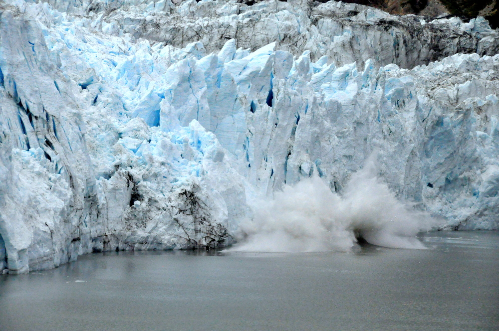
Two glaciers in particular often draw attention from scientists: Pine Island Glacier and Thwaites Glacier. These massive rivers of ice flow from the interior of West Antarctica toward the ocean. Over the past few decades, both glaciers have accelerated and retreated inland as their grounding lines shifted backward. While the changes may seem slow on a human time scale, they represent significant movement in glaciological terms.
What makes West Antarctica especially vulnerable is the geography beneath the ice. Much of the bedrock in this region lies below sea level. As glaciers thin and retreat, warm ocean water can push farther beneath the ice shelves that extend over the sea. This interaction can gradually weaken the glaciers from below, allowing them to slide more quickly toward the ocean.
By contrast, large portions of East Antarctica appear far more stable. The ice sheet there sits on higher ground and is generally protected from direct ocean intrusion. While researchers continue to monitor the region closely, it has shown far fewer signs of rapid change in comparison to the West.
Understanding these regional differences is essential when discussing how much ice Antarctica has lost. Headlines can sometimes make it seem as though the entire continent is melting at once. In reality, Antarctica behaves more like a patchwork system. Some areas remain relatively steady, while others experience faster glacier retreat.
This uneven pattern highlights why scientists rely on long-term satellite monitoring. By mapping these changes year after year, researchers can identify which glaciers are shifting and which ones remain stable. These observations form the foundation for ongoing polar ice melt updates. This helps scientists refine their predictions about future changes in the Antarctic ice sheet.
Why the Ocean Plays a Critical Role
When people think about melting ice, they often imagine warmer air temperatures causing glaciers to thaw from above. While atmospheric warming does play a role in certain polar regions, the primary driver behind much of today’s Antarctic ice loss lies beneath the surface of the ocean.
Scientists have discovered that relatively warm currents of seawater circulate the Antarctic continent. These currents, often referred to as Circumpolar Deep Water, flow hundreds of meters below the ocean’s surface. In some regions, the currents rise toward the coastline and slip beneath floating ice shelves.
Once that warmer water reaches the underside of the ice, it can slowly melt the glacier from below. This process is known as basal melting. Even a small increase in water temperature can significantly affect the stability of ice shelves because the melting occurs across enormous areas.
Ice shelves act like natural barriers that hold back the glaciers behind them. When these shelves thin or weaken, the glaciers feeding into them can begin moving faster toward the sea. Over time, that acceleration contributes to greater ice loss in Antarctica as grounded ice flows into the ocean.
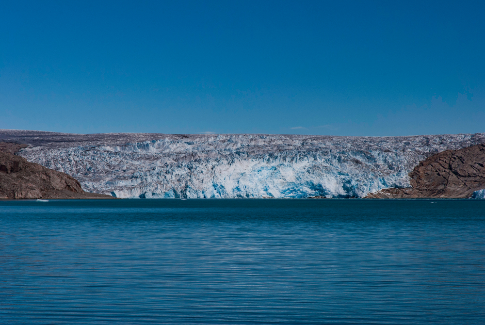
Image credit: Shutterstock.
Researchers studying the climate change effects on ice sheets have found that this ocean-driven melting explains many of the glacier retreats observed in West Antarctica. Satellite measurements show that ice shelves in the region have thinned substantially over the past few decades, allowing glaciers such as Thwaites and Pine Island to speed up.
At the same time, the relationship between ocean currents and Antarctic ice remains complex. Ocean circulation patterns shift naturally over time, and scientists are still working to understand how these variations interact with long-term climate trends. Nevertheless, most experts agree that ocean warming is a major factor shaping modern polar ice.
Because the ocean plays such a powerful role, studying Antarctica requires collaboration across multiple scientific fields. Glaciologists examine the behavior of the ice itself, while oceanographers analyze the currents moving beneath it. Together, their work helps reveal the interconnected systems driving change in Earth’s coldest continent.
How Satellites Help Scientists Track Antarctica’s Changing Ice
For much of the twentieth century, studying Antarctica was an enormous challenge. Researchers could only observe small portions of the continent at a time, often during short summer expeditions. Vast stretches of the Antarctic coastline remained largely unexplored, making it difficult to answer basic questions about how much ice Antarctica has lost or how glaciers were evolving over time.
The rise of satellite technology changed that. Today, scientists rely on a network of Earth-observing satellites that continuously monitor the polar regions. These instruments orbit the planet and gather detailed information about glacier movement, ice thickness, and surface elevation. As a result, researchers can track subtle changes that would otherwise go unnoticed.
One of the most valuable tools for studying Antarctica’s ice loss is satellite radar. Unlike regular cameras, radar instruments can penetrate clouds and operate during the long Antarctic winter when sunlight disappears for months at a time. By sending microwave signals toward the ice surface and measuring the reflections, satellites can detect small shifts in glacier movement.
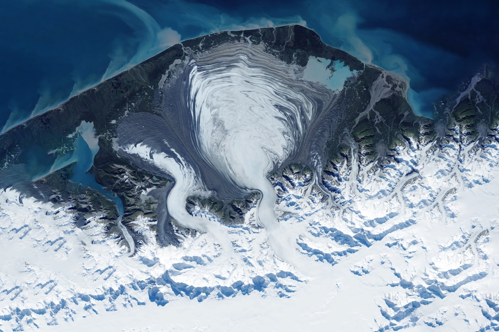
Over time, these observations build a detailed picture of how Antarctica’s ice sheet behaves. Scientists compare satellite images taken years or even decades apart to identify patterns of retreat or stability along the continent’s edges. The recent study that inspired headlines about ice loss equivalent to ten Los Angeles–sized areas relied heavily on this type of long-term satellite analysis.
Researchers examined data spanning more than thirty years, mapping the position of grounding lines across nearly the entire Antarctic coastline. The results revealed where glaciers had pulled back from the ocean and where they remained relatively unchanged. Without satellite monitoring, detecting these continent-wide patterns would be nearly impossible.
Another important technique involves satellite altimetry, which measures tiny variations in the height of the ice surface. If a glacier thins over time, its surface elevation drops slightly. Satellites can detect these small differences, allowing scientists to estimate how much ice volume is changing.
These measurements play a critical role in producing reliable updates. They also help researchers understand how glacier behavior varies from one region to another. Some glaciers accelerate rapidly, while others remain stable for decades. Satellite data provides the evidence needed to distinguish between these trends.
The technology continues to evolve as well. Newer missions from agencies such as NASA and the European Space Agency are providing increasingly precise measurements of the Antarctic ice sheet. These instruments allow scientists to observe glacier dynamics in near real time, offering a clearer picture of the climate change effects on ice sheets.
By combining decades of satellite observations, researchers now have one of the most comprehensive views of Antarctica ever assembled. This growing dataset is essential for understanding long-term trends in ice loss in Antarctica and predicting how the continent may change in the future.
What Antarctica’s Ice Holds for the Planet’s Future
Although the recent measurements represent only a small fraction of Antarctica’s total ice sheet, scientists still view them as important signals. The Antarctic ice sheet is the largest reservoir of freshwater on Earth. If all of its ice were to melt, global sea levels would rise by roughly 58 meters, reshaping coastlines around the world.
Of course, such a complete melt would take thousands of years under even the most extreme scenarios. Still, researchers study Antarctica’s ice loss carefully because certain regions of the continent appear more vulnerable than others. If key glaciers continue to retreat, they could contribute to a gradual sea level rise over the coming centuries.
West Antarctica is often the focus of these concerns. Several of its glaciers rest on bedrock that slopes downward beneath the ocean. When grounding lines retreat into these deeper basins, the glaciers can become less stable and flow faster toward the sea. Scientists call this process marine ice sheet instability, and it is one of the main reasons glaciologists pay close attention to ice loss in Antarctica.
The famous Thwaites Glacier, sometimes nicknamed the “Doomsday Glacier,” illustrates this concern. The glacier is roughly the size of Florida and contains enough ice to raise global sea levels by more than half a meter if it were to collapse entirely. Researchers monitoring Thwaites have observed thinning ice shelves and retreating grounding lines over the past few decades.

However, it is equally important to recognize that Antarctica is not changing uniformly. Large sections of the continent remain stable, and some areas even experience small increases in snowfall that help offset losses elsewhere. These regional differences complicate predictions about the ice sheet’s future.
When discussing how much ice Antarctica has lost, scientists often emphasize that the continent’s behavior depends on a combination of factors. Ocean temperatures, atmospheric conditions, snowfall patterns, and the shape of the underlying bedrock all influence glacier stability. As these variables shift, different regions of Antarctica respond in different ways.
For this reason, long-term monitoring remains essential. Each new polar ice melt update adds another piece to the puzzle, helping scientists refine their understanding of the Antarctic ice system. Over time, these insights will improve predictions of sea-level rise and the broader effects of climate change on ice sheets worldwide.
The “Ten Los Angeleses” Comparison
Saying Antarctica has lost ice equal to ten Los Angeles–sized areas sounds like an alarming statistic. However, the comparison serves a specific purpose. Scientists and journalists often translate large scientific measurements into familiar references so readers can better understand the scale of environmental change.
In this case, the comparison highlights how much the edges of Antarctica’s glaciers have shifted since the early 1990s. When researchers analyzed three decades of satellite data, they found that grounding lines around the continent had retreated in several key regions. Added together, those changes amount to an area of roughly 12,000 square kilometers, which scientists equated to about ten Los Angeles–sized regions.
The figure does not mean that giant chunks of ice the size of cities suddenly broke away from the continent. Instead, it reflects a gradual retreat along the coastline where glaciers meet the ocean. These slow shifts are part of the ongoing story of Antarctica’s ice loss, which scientists track carefully to understand how glaciers respond to environmental changes.
Even though the total area represents only a small fraction of Antarctica’s vast ice sheet, the findings still provide valuable insight. The edges of glaciers often react first when conditions begin to change. As a result, monitoring these areas helps researchers identify early warning signs of instability.
For scientists studying ice loss in Antarctica, the most important takeaway from the research is not the headline but the detailed map of grounding line movements. Those maps show where glaciers are retreating, where they remain stable, and where further investigation is needed.
The study also highlights how complex the Antarctic system truly is. While some glaciers are losing ice due to warming ocean waters, many other areas remain relatively unchanged. In fact, the majority of grounding lines around the continent have stayed stable over the past thirty years.
This uneven pattern reminds us that Antarctica is not a single uniform block of ice. Instead, it is a vast and dynamic environment shaped by ocean currents, atmospheric conditions, snowfall patterns, and the unique geography beneath the ice sheet.
Read More: The Cities That Could Disappear by 2030 Due to Climate Change and Rising Seas
Looking Beyond the Headline
Scientists studying the ice loss in Antarctica rely on a combination of satellite technology, ocean research, and glaciology to monitor one of the most remote environments on Earth. Their work reveals that the Antarctic ice sheet is constantly evolving. Some regions are retreating, others remain stable, and many are still being studied in greater detail.
The continent holds the largest supply of freshwater ice on the planet, and its glaciers play a significant role in regulating global sea levels. By monitoring polar ice melt updates, researchers can better anticipate how coastlines and ecosystems may change over the coming decades.
At the same time, the research shows that Antarctica is far from simple. While certain glaciers in West Antarctica are retreating more rapidly, much of the continent continues to show remarkable stability. These differences highlight the importance of ongoing observation and scientific collaboration.
As satellite monitoring continues and new discoveries emerge, researchers will keep refining their understanding of the effects of climate change on ice sheets. Each new study adds insight into the planet’s most remote and mysterious continent. And with every update, the world gains a clearer picture of how Antarctica is changing, and how those changes will affect the future of our planet.
A.I. Disclaimer: This article was created with AI assistance and edited by a human for accuracy and clarity.
Read More: As Global Tensions Rise, Prices For These Things Are About To Skyrocket
Trending Products

Red Light Therapy for Body, 660nm 8...

M PAIN MANAGEMENT TECHNOLOGIES Red ...

Red Light Therapy for Body, Infrare...

Red Light Therapy Infrared Light Th...

Handheld Red Light Therapy with Sta...

Red Light Therapy Lamp 10-in-1 with...

Red Light Therapy for Face and Body...

Red Light Therapy Belt for Body, In...

Red Light Therapy for Shoulder Pain...
